
A few years ago, I needed to get to Hamburg urgently. I didn't know my way around the city so I depended on my navigation device—and was thoroughly disappointed. The display stayed black and has remained this way ever since. In my distress, I turned to Google Maps, for the first time, and boy was in for a shock. The app sucked by battery dry like an electric blanket and I ended up in some shady harbor district, with even more shady characters eyeballing my factory-fresh rental car. The whole time, Google Maps advised me to turn around. Eventually, I was just as lost as the navigation service. It was a friendly local who ultimately came to my rescue. A lot has changed since then. Google Maps is now celebrating its 15-year birthday and, what started as a digital map, has become a powerful exploration tool.
Years after my Hamburg trip, I visited the wonderful Iceland. By then, the service was mature enough to guide me through the country without a single hiccup. I navigated safely through lava fields and unpopulated areas, even unusual town names like Sauðárkrókur, entered without the special characters, posed no issues. And when I encountered traffic circle after traffic circle in Reykjavik, Google Maps kept its cool—and has been my route planner of choice ever since. The service is kind of a joint effort. Every cellphone with location services enabled contributes to the overall reliability of the system by transmitting its velocity and location at regular intervals, helping Google Maps quickly detect and signal traffic jams among other things. An artist recently fooled the system by manually hauling a handcart with 99 GPS-enabled cellphones through a street. Google apparently considered the affair a traffic jam. If you don't like your location being constantly tracked, you can disable location services on your device. However, this means Google will receive less data and nifty features like route planning, personalized maps, recommendations based on recently visited places or real-time updates on commuter traffic will be unavailable to you. It's either more privacy or more comfort. The decision is yours!
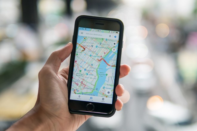
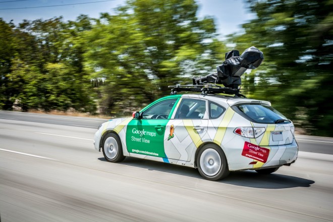
Google Maps has become so much more than the simple map we used to have in our cars. The built-in route planning, which supports various modes of transport from using a car to walking, is constantly improving. Traffic news are always up to date, unlike many rival products, and the service has turned into somewhat of a tour guide for many. On top, information on public transport networks is readily available for multiple countries. Aside from normal and topographic view, Google Maps also features a zoomable satellite view to give you a bird's eye view of your surroundings. Add to that the 3D and Street View functions and you're looking at what is arguably the most comprehensive digital representation of our world. Street View in particular has met with fierce criticism in the past because of the many Street View cars that roam the world taking photos of their surroundings, including private homes and residents. Over the years, various countries with strict privacy laws have forced Google to blur so many parts that the service has become almost unusable in some regions.
But there's also an economic impact to Google Maps. Its rating and recommendation system, targeted at restaurants, stores and even government institutions, allows users to rate the quality of said places. If you're in an unfamiliar location and looking for a place to eat, Google Maps will instantly present you with a list of restaurants in your vicinity. Naturally, places rated five stars are more likely to attract visitors than less fortunate establishments. The service can be a big help but it's also prone to abuse, e.g. fake reviews and ratings, especially for low-digit entries. Many a one restaurant owners have encouraged their friends and family to provide euphoric ratings and reviews—and there have also been cases of mud-slinging by competitors or unfavorable manipulation of opening hours. Nowadays, Google Maps is big enough to decide the economic fate of a business, which is why the court cases will keep coming. Here's a simple self-experiment: Would you visit a hotel after you've read about rotten food and bed bugs in the reviews? Rmember, the information could be false!
Google even try to guess your future needs, based on detailed knowledge of your habits and preferences. That's why the recommendation for that Italian restaurant always pops up just as you're within walking distance.
Google Live View, on the other hand, is relatively new and meant for navigating cities on foot. You first create your route on your cellphone and then switch to "Live View". Once you rotate your device, Google will use the built-in camera to recognize your surroundings and add arrows and pointers (augmented reality) to guide you to your destination. It works quite well, but has the downside of you having to hold up your cellphone the entire time—and looking like an idiot in the process. The software also supports custom maps with your favorite locations based on prior saved addresses or individual commutes. It will even notify you when it's time to go or point out obstacles along the way. Other noteworthy features include details on charging points for electric vehicles, busy hours for restaurants or places of interest and, privacy advocates take notice,a detailed movement profile. Once a map has been downloaded, Google Maps also works offline—a significant advantage in deadzone-ridden areas.
Once you're logged into your Google account on your PC, you can transfer your route across device boundaries, provided the target device is linked to your account. This makes planning your next vacation so much more stress-free. There's no 100% feature parity across devices though, e.g. Google Flights is only available on PC. But did I mention everything is fully voice-controllable or that there are even indoor maps available for various major buildings and malls, including parking garages? Calling this extensive package a map service is a major understatement. It has evolved into a full-fledged navigation and shopping companion—provided we let it access various aspects of our lives. Whether you use Google Maps, simply admire the technology or shudder at its scope, a lot has happened over the past 15 years. I'm positive the next feature enhancements and disruptive synergies are only a few months away.
What I would like to know: Do you use Google Maps? What are your thoughts on the service?


Yeah, Google maps. Sometimes you can't hear what is being said. Sometimes their idea of a path isn't the brightest one. Compass doesn't work on it, so that was a waste.
I'd like to see it allow for a better option for directions. Something along the lines of, I know it up to here. Also mute would be nice, if it won't shut off.
Google is always listening, why doesn't it be quiet when you say? That'd be a cool feature. "Ok, turnoff, I'm done would be good too; seeing we can't use our hands on the phone.
Sometimes, it actually gets you there in a decent amount of time. For that, I use it. It has improved, it gets many of the street names close. Sometimes you look at the map & wonder who fed that information in to it?
Thank goodness it doesn't have any hand drawn extensions, whew.
Mainly use Waze and Google Maps only very occasionally, but might try it again if Waze drops again during a long road trip.
I am a geographer so I love all mapping tools, including this one.
I have a data blog where I discuss limitations of mapping, how to find mapped data, and so on, http://spatialreserves.wordpress.com One limitation that you might find interesting is the offset between the imagery and the streets in Google Maps in China. Also there is a book on the creation of Google Maps from Keyhole Earth Viewer, called Never Lost Again. Fascinating history and technology book. --Joseph K
I use it all the time i am heading to some unknown place ,it is brilliant, beats the old paper maps that you had to fight with.
i give them 8/10 i very rarely look at it but the voice directions work well for me.
In 1998 our family took a trip from San Diego CA to Europe. I bought a GPS that connected to my Laptop and purchased maps from a company out of the Netherlands. In those days the GPS satellites were sparse and you could lose track of where you were at any time. The maps were not detailed either. Since then we have made several more trips each time renting a motor home in Germany and travelling between NL and IT. The most recent time was in 2017 and I used a product called "Sygic" With "Sygic" you to download map detail by country. This way you do not need cell data service to get map information. I use it in the USA as well. https://play.google.com/store/apps/details?id=com.sygic.aura&hl=en_US
Google Maps works better for me than Waze, but it cost me hours of driving on a winter road trip, as it's not smart enough to know about seasonal road closures, so kept routing me to roads not open in winter, both in the western US and Canada. When it did work, it couldn't take into account extra time for winter driving conditions. So, it's a tool, but if it would use State Department of Transportation data about such things, it would be more useful when driving off the freeway in mountainous areas.
Gosh, what a sensible comment from Trevor. Especially for the UK, where we have 14-18th century roads as we are a small island and had the first railway system in the world, thus low bridges. Most of our transport system was a world first so we cannot alter much, like weight restricted bridges. Foreign and local LGV driver regularly screw up. We also have lots of level crossings and Google will guide drivers onto the tracks. Yup we are thick as well.
So as Trevor said, please Google do this for your 'home' country, remember your brain genes were mostly from us :-) Er, and you were given the tools by a chap called Tim !!!!!!!!!!
I do like Google Maps and find it strange Google doesn't do HGV type maps ie: Height, Weight, Width limits. Yes, you can get various Apps but some are expensive. Please Google, Please??
It is not bad, but still have a lot of issues.. I have a house on Adriatic coast, in a small fisherman's willage Vinisce, and entering my address on Google maps points to a wrong place, some 500m away at neighbour's ugly old house (entering geo codes instead, works fine). I am in apartment renting, so informing you about address (legaly correct and utilized) will only lead you to my competitors, instead of finding me.. It is also hard to get something changed by informing their team of this error - 8 messages sent so far, and checking, checking..no correction yet.. So, I am even thinking of putting them to court, because it can (and possibly does) hurt my business showing ugly property on street view, instead of a beautiful renovated house.. The big cities.. well, it seems to work better, but, is it not mostly about finding your destination in smaller places, with less helping physical signage..? Open Street Maps, on the other side, work perfectly in all places I needed, and any correction can be done instantly..
What GMaps need to improve, as I see it, is acting quickly and more efficiantly in a need of corrections to be done, and then it would be much more helpful.. BR
I use Google Earth and Google Maps a lot considering my only vehicle is a mobility scooter. It helps me to check if a town has dropped kerbs beyond its High Street and whether it is worth a visit to take photographs. It helps me find disability parking for my friend. Sorry for the pun but we'd be lost without it. :)
Love Google Maps! Use it often and appreciate being able to use it off line when heading into dodgy coverage areas.
Also enjoy taking world online trips with the wonderful photographs on Earthview!
Hi Sven,
Thank you for the interesting description of your trip.
Google maps may be worthwhile in Britain and Europe but fail miserably in a large part of Australia, roads heading into the sea, a great deal of incorrect locations including mine, and I had to find a method of advising Google five years ago which took several weeks to be rectified, and many are still incorrect
I look for destinations on Google Earth and use a GPS, an exceptionally accurate and easy to use free product called WAZE, available on Google Play Store.
MapQuest, Waze and even Bing have more features that Google.
Hi Sven, Yes its amazing how things change. I remember when we used to get Windows 1 floppy disks free with all our XT PCs. I used to throw them in a box for recycling. Now windows is used by everyone which is not too surprising as I can always remember after shipping a lot of our PCs the first question we would get from the customer when faced with a black screen and a flashing cursor, was, what do I do now? I find myself using Google maps a lot and it is almost indespensible. The big problem is as you say having to hold your phone, where are the Google glasses!
Yes, I use Google Maps. My car has GPS integral to the entertainment system but Google Maps far exceeds that system's capability.
In addition to the maps, the little add-ons like the speed limit block and the night view help a LOT!
I use G maps almost daily. I use it in car when my TomTon can’t find a place(at least 25% of the time), find out where businesses are that I’m contemplating visiting, and finding out where things are that are in the news, to name a few.
Excellent service
I was the Project Officer responsible for the European projects Socrates and Promise when they demonstrated route guidance for the first time in the world at Gothenburg, Sweden in 1992. They wanted to do it in London but it was not legal for drivers to be able to see the visual displays at that time.
Everyone was wondering about the human/machine interface because it was widely regarded unsafe to look at maps while driving so different methods were tried. Audio advice only, just visual arrows indicating the direction to turn that popped up as you approached junctions and a 3d wireframe map from the driver's perspective (similar to TomTom's display).
I recorded some of the drivers while they used the various options on my video recorder and the results were very telling and almost the opposite to expectations.
The audio was a problem because messages were sometimes missed. The worst was probably the arrow method because the instructions popped up at sometimes inconvenient moments and they didn't correspond to the actual road layout when there were multiple exits or different amounts of steering input required. The drivers using both of these systems were noticeably disturbed.
The drivers using the 3d map were the least disturbed by the system, if at all, because they could glance down when they felt safe to do so and as the view was similar to theirs, it was quickly interpreted. These drivers were the most relaxed of all.
Google maps has come a long way since the 1992 pilot test in Gothenburg where mobile transmitters were used as location points because GPS wasn't properly available then. They now give dynamic route guidance that modifies routes according to current traffic conditions so is a must for drivers in busy cities. However, I believe that they've actually missed a trick by only presenting an overhead map view rather than including the 3d drivers view as an option but perhaps, as it's free to use, we shouldn't be too critical.
I agree, Google Maps has become my first choice for finding a route quickly and effectively. I like the feature about "leaving" at a date and time the most.
But, Google has become very delayed in recognising a traffic jam / build up; and also at showing that the traffic has cleared. For this I find Waze and Here much more effective and close to real time.
In South Africa we have traffic cameras on all the major routes - and these pictures (not a live feed) are available to view to everyone. With a 2-3 minute delay in showing the picture (I guess they need to render it from the live video stream), you have an almost real-time view of the traffic.
Comparing this to Google Maps' representation of the traffic, shows the delay in Google Maps (sometimes up to 15 minutes) - which does not make sense, as Google Maps is gathering information from a lot of mobile phones to show actual movement. Again, for this Waze and Here are closer to real-time.
whilst the mapping is quite good, I find the colours of the roads do not show up well against the background colour. White on pale grey is a poor choice of colour contrast.